Social Studies & Visual Arts
The Five Major Oceans

Grade Level: 2nd
Time: 45 minutes
Lesson Background:
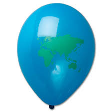
In this lesson, I want students to be able to identify the five major oceans in the world on a map. This lesson is meant for students who are visual and tactile learners. Students are going to make their own globe out of a balloon and label the countries and oceans of the world.
Big Ideas, Key Concepts, Competencies: Water is all around us and we need it to survive. There are different types of bodies of water in the world but the biggest bodies of waters are oceans. There are five of them and they are located all around the world.
Teacher Knowledge: Teacher should know the names of the different oceans and where they are located on a globe and a map. Teacher should also know the different types of climates of the oceans and the different countries that border each ocean. The oceans are Atlantic, Pacific, Arctic, Indian, and Southern (added in the year 2000).
Pennsylvania Curriculum Standards:
Academic
Objectives:
Materials:
Teacher:
Student:
Step-By-Step Procedure:
Engagement/Introduction
I will engage the students by having them inflate their own balloons and asking students to locate and draw the prime meridian, the equator, and the continents of the world on the balloon (students have been exposed to a world map and know where the continents are located, students will also have the teacher and the enlarged map as reference). I will go through every continent with them using hand placement. For example, your left hand is where you should label North America and your right hand should be on Asia. Once they have all the continents drawn and labeled, I will write down the names of the five oceans on the board: Atlantic, Pacific, Arctic, Indian, and Southern (added in the year 2000) and discuss the countries it borders.
Explicit Instruction
I will show the location of every ocean on the enlarged map and point out the countries that border each ocean:
Modeling
I will then show students my pre-made balloon globe. This balloon serves as a personal globe and shows an approximate location of all the continents. I will then model and think aloud exactly how I would label the oceans. “I am going to start with the Pacific Ocean. I know that this ocean is located between Asia and North America. I will look for these continents and write the name of the ocean in between these continents.”
Guided Practice
I will then ask students to label the Pacific Ocean with my help. I will ask students to reference their personal maps or enlarged class map to continue labeling their balloon globe. If students need assistance I will serve as a guide to help them. Once students are finished labeling their globes, students will use the yarn to tie the balloons and I will hang the globes from the ceiling.
Evaluation
Students will receive the above map as a worksheet with the ocean names crossed out. Students must fill out the the names of each of the oceans. This is a formal way for me to assess if students know the location and spelling of each of the oceans. Also, the finished balloon globe will be an informal observation of the locations of each ocean.
Differentiation
Time: 45 minutes
Lesson Background:
In this lesson, I want students to be able to identify the five major oceans in the world on a map. This lesson is meant for students who are visual and tactile learners. Students are going to make their own globe out of a balloon and label the countries and oceans of the world.
Big Ideas, Key Concepts, Competencies: Water is all around us and we need it to survive. There are different types of bodies of water in the world but the biggest bodies of waters are oceans. There are five of them and they are located all around the world.
Teacher Knowledge: Teacher should know the names of the different oceans and where they are located on a globe and a map. Teacher should also know the different types of climates of the oceans and the different countries that border each ocean. The oceans are Atlantic, Pacific, Arctic, Indian, and Southern (added in the year 2000).
Pennsylvania Curriculum Standards:
Academic
- 7.1.B: Identify the seven continents and five oceans
- 9.1.I. Create and exhibit visual art
Objectives:
- Students will be able to label the five oceans on a map or globe
- Students will be able to identify where each ocean is located and what countries surround it
Materials:
Teacher:
- Light blue balloons that have not been inflated (one for teacher to use as a model and one for each student)
- Permanent markers (one for model and one for each student)
- Enlarged world map (using a screen projector, poster, or class map)
- Yarn or string
Student:
- One balloon that has not been inflated
- Copy of a world map
- Permanent marker
- Yarn
Step-By-Step Procedure:
Engagement/Introduction
I will engage the students by having them inflate their own balloons and asking students to locate and draw the prime meridian, the equator, and the continents of the world on the balloon (students have been exposed to a world map and know where the continents are located, students will also have the teacher and the enlarged map as reference). I will go through every continent with them using hand placement. For example, your left hand is where you should label North America and your right hand should be on Asia. Once they have all the continents drawn and labeled, I will write down the names of the five oceans on the board: Atlantic, Pacific, Arctic, Indian, and Southern (added in the year 2000) and discuss the countries it borders.
Explicit Instruction
I will show the location of every ocean on the enlarged map and point out the countries that border each ocean:
- Pacific Ocean: located between Asia and North/South America.
- Atlantic Ocean: located between Africa/ Europe and North/South America
- Indian Ocean: located below Asia, above Antarctica, in between Africa and Australia
- Southern Ocean: above Antarctica.
- Arctic Ocean: the most Northern part of the globe extending between Europe, Asia and North America.
Modeling
I will then show students my pre-made balloon globe. This balloon serves as a personal globe and shows an approximate location of all the continents. I will then model and think aloud exactly how I would label the oceans. “I am going to start with the Pacific Ocean. I know that this ocean is located between Asia and North America. I will look for these continents and write the name of the ocean in between these continents.”
Guided Practice
I will then ask students to label the Pacific Ocean with my help. I will ask students to reference their personal maps or enlarged class map to continue labeling their balloon globe. If students need assistance I will serve as a guide to help them. Once students are finished labeling their globes, students will use the yarn to tie the balloons and I will hang the globes from the ceiling.
Evaluation
Students will receive the above map as a worksheet with the ocean names crossed out. Students must fill out the the names of each of the oceans. This is a formal way for me to assess if students know the location and spelling of each of the oceans. Also, the finished balloon globe will be an informal observation of the locations of each ocean.
Differentiation
- Writing labels in native language
- Labeling continents OR oceans
- Labeling equator and prime meridian only
- Labeling where they live now
- Let the students let the air out and watch the balloon fly before the lesson
© 2013 Dana Daniel
